


The Flies:
The custom fly selection you are about to order will consist of a dozen hand selected flies from the fly bins of Anglers All. These flies will be selected by an Anglers All staff member using the knowledge, research and experience of the collective Anglers All team, based on the month you will be fishing in the Colorado high Country. These selections will include nymphs, midges, dry flies and a streamer or two. Your package will include your ordered flies in a reusable Anglers All fly cup, as well as a list with names and descriptions of your flies. The dozen you will receive will not guarantee fish caught, but include the flies we would bring to the water if we were to fish it with you!
The Colorado High Country:
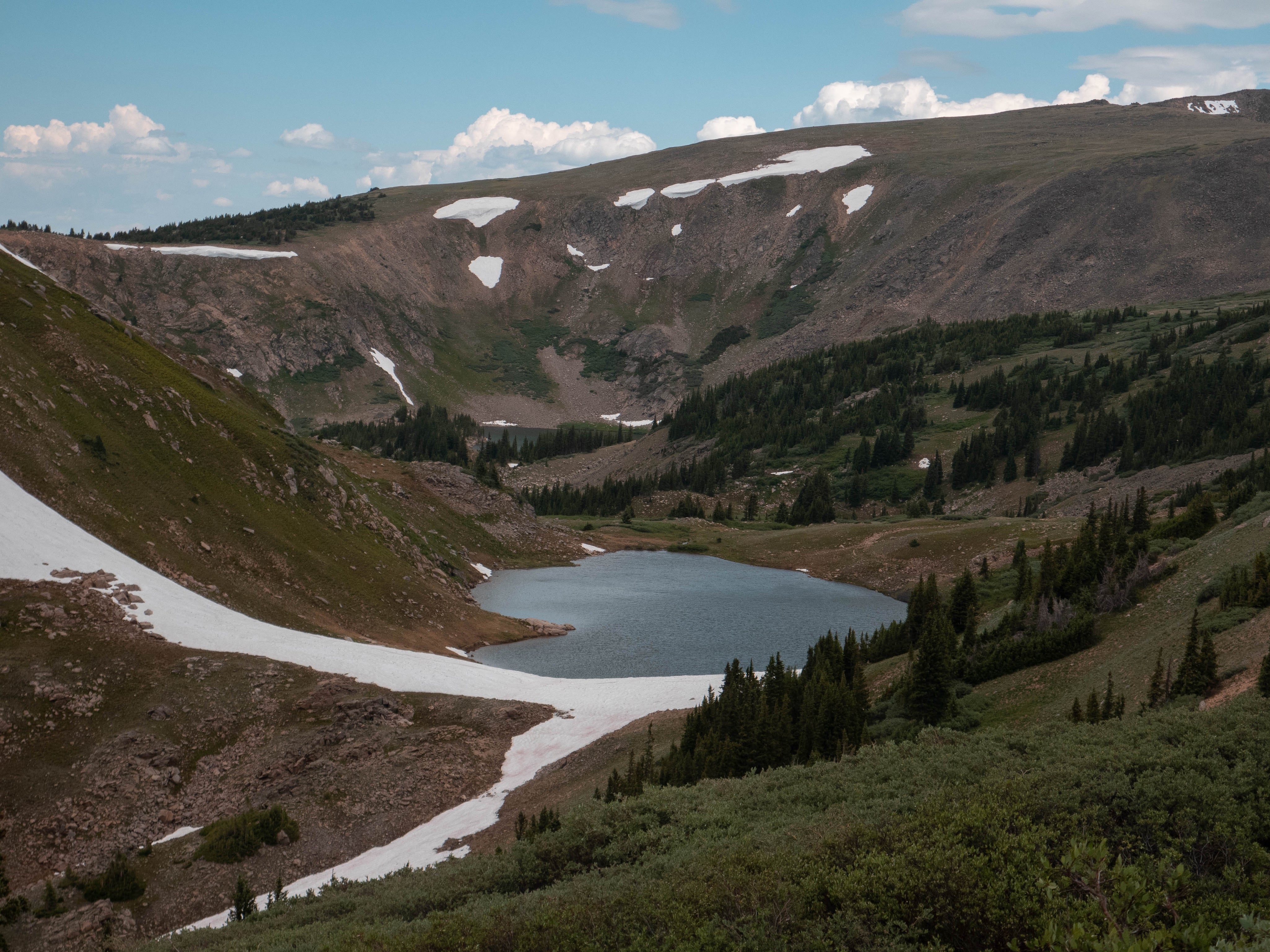
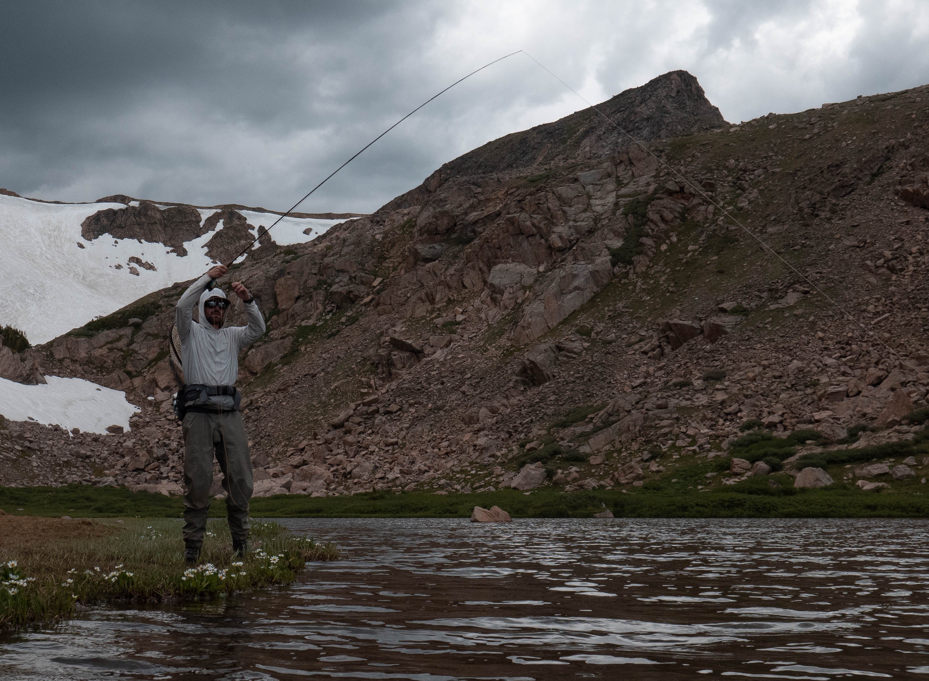
Nothing we could say in this description could do justice to the majesty of the Colorado high Country. Stunning vistas, magnificent peaks, and breathtaking views draw in lovers of the outdoors like moths to a light. And while the hikers flock to the high Country in search of new trails and seclusion from the metro Denver crowds, anglers are drawn to the mountains for another reason: hungry, opportunistic trout that don’t see much pressure.
Fishing the high country is a game of timing. Lakes at different elevations will thaw out at different times, which can differ from year to year depending on snowpack, runoff, weather conditions, the shade provided by mountain peaks, etc. Ice-off can be unpredictable and can force anglers into a trial & error exploration process. But when it comes to fishing at high elevations, putting in work to get to the fish is the cost of entry.
While you’ll find mostly rainbows, browns, and cutbow trout at lower elevations, these species are mostly nonexistent in the high country. Anglers that are willing to hustle up into the hills are usually looking for one species in particular: cutthroat trout. Whether they were stocked historically or harbor native populations, many Colorado alpine lakes and streams are teeming with aggressive, feisty cutthroat. The fisheries that don’t hold cutthroat exclusively will usually be full of brook trout, or a mix of the two species living in harmony. Regardless of the resident population, you won’t be catching the same trout you find in heavily pressured stretches of the South Platte.
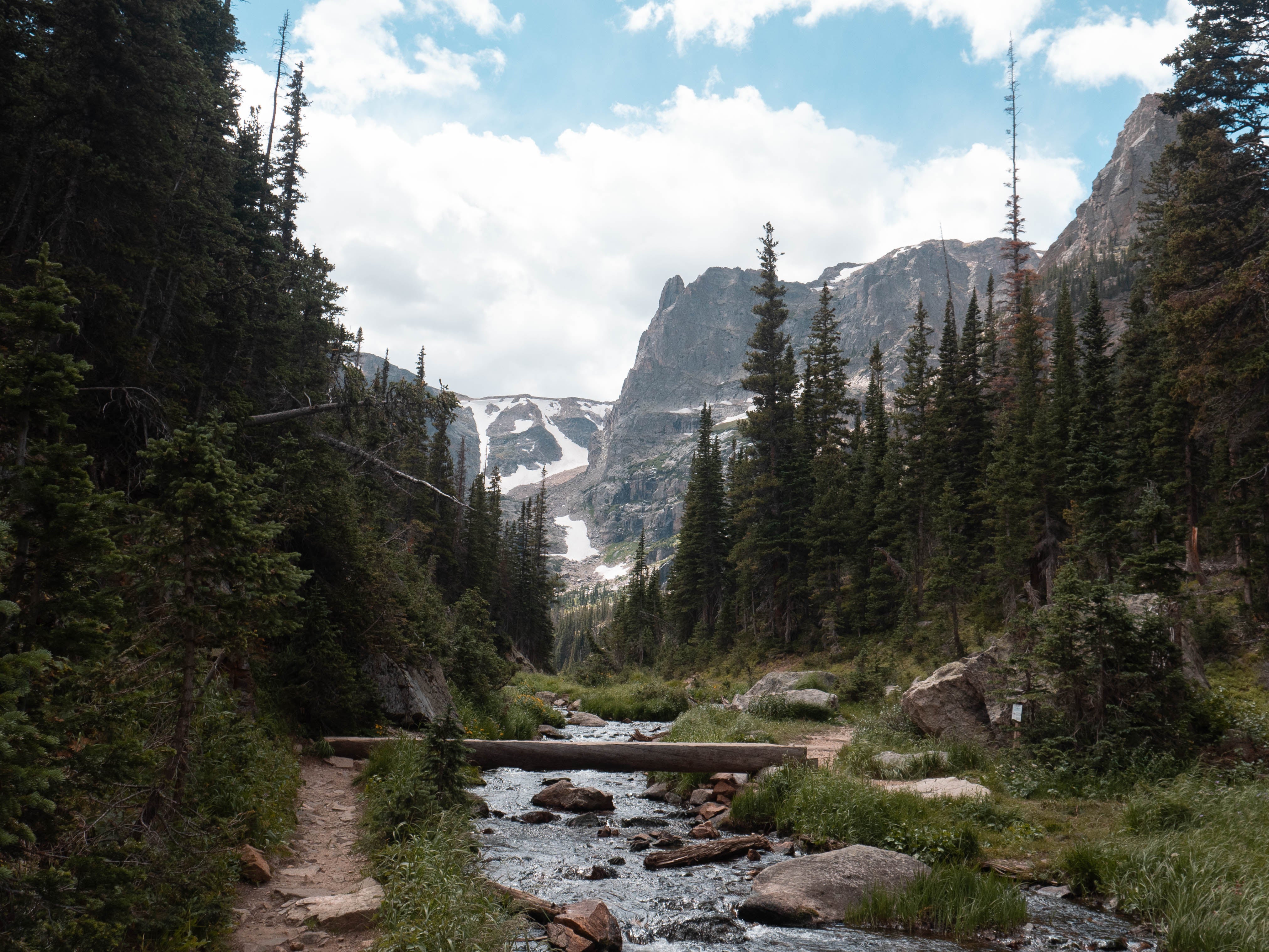
Alpine, Explained:
Whenever you hear someone talk about catching trout in the mountain lakes of the Rockies, the term that often comes up is “alpine”. While “alpine” is used by many anglers to describe the high elevation fisheries they visit that are inaccessible for ⅔ of the year and may require a difficult drive and/or hike to access, not all high elevation fisheries are truly “alpine”. We still generally refer to high mountain lakes above 8,000 feet as “alpine lakes”, but it’s also important to note the technical differences between the “alpine” and the real alpine.
MONTANE - 5,600 - 9,500 feet - Characterized by large meadow valleys and slopes. Supports the widest range of life.
SUBALPINE - 9,000 - 11,000 feet - Evergreen forests and mountain lakes sustain life in this chilly, demanding environment. The lakes in the Subalpine regions are generally the easiest to access and receive the most foot traffic.
ALPINE (TUNDRA) - Above 11,000 feet - Characterized by rugged terrain, cold temperatures, & high winds. The only life that can be found at these elevations takes the form of a few species of hardy animals and ground-hugging vegetation.
Best Access Points:
If we listed every access point to the Colorado high country in this product description, it would go on for thousands of words. The Centennial State has so many wilderness areas to explore, an angler could spend an entire lifetime and still not come close to seeing it all.
The best way to start tackling the Colorado high country is through the use of topographic maps. Do your research to figure out which lakes & streams you’d like to target (CPW’s fish surveys are a good starting point) and purchase a map for the area in which those fisheries lie.
Google Maps can work also, but does not list the hiking trails or the old access roads that make the backcountry areas accessible. Plus, (and more importantly) topographic maps do not rely on cell service or battery life to function. Speaking from experience here: do NOT rely on your cell phone in the wilderness.
You can also reference hiking books and websites (AllTrails.com can be helpful) to get a better understanding of the difficulty of the trail you’re considering. These resources can also give you information regarding access roads, as two roads on a topographic map may appear similar on paper, but can be wildly different in reality. Not all 4WD roads are made alike!
That said, here are a few areas to consider when planning your next (or maybe first) high country adventure:
Rocky Mountain National Park – No need for a winded explanation on this one. RMNP is an iconic paradise visited by hordes of tourists and locals alike. All the information you need can be found on the National Park Service website. Be sure to call ahead to check on road/trail closures and bring some extra cash to pay the entry fees.
James Peak Wilderness – The James Peak area became part of the National Wilderness Preservation System in 2002. James Peak (13,294 feet) was named for Edwin James, an American physician and botanist who traveled to Colorado on the 1819 U.S. Army expedition led by Major Stephen Long. James was the first botanist to describe many of the plants of the Rocky Mountains.
Bordered by Indian Peaks Wilderness to the north, the 17,015-acre James Peak Wilderness is located within Boulder, Gilpin and Clear Creek counties. Adjacent to the Continental Divide on the eastern slope, James Peak Wilderness includes several peaks over 13,000 feet and more than a dozen alpine lakes.
The area's elevation ranges from 9,200 to 13,294 feet, which includes upper montane, sub-alpine, and alpine ecosystems of the Rocky Mountains.
Indian Peaks Wilderness – The Indian Peaks Wilderness was designated as a protected wilderness area in 1978 by an act of Congress. It encompasses 73,391 acres with over 50 lakes, 28 trails covering 133 miles, and six passes across the Continental Divide. Elevations in these wilderness areas vary from 8,400 to over 13,500 feet, from montane to sub-alpine and alpine life zones. It borders the James Peak Wilderness to the south and Rocky Mountain National Park (RMNP) to the north.
The Indian Peaks Wilderness is located a 45 minute drive west of Boulder and 1-hour drive northwest from Denver. Between Memorial Day and Labor Day each year, approximately 150,000+ visitors make the Indian Peaks Wilderness one of the most heavily used wilderness areas in the country due to its close proximity to the Denver/Boulder metro area.
Mount Evans Wilderness – Mount Evans Wilderness was designated by the United States Congress in 1980 and now spans 74,401 acres. Mount Evans Wilderness area includes two 14,000-foot peaks (14,264' Mt. Evans and 14,060' Mt. Bierstadt) and contains alpine tundra, bristlecone pines, bighorn sheep, and mountain goats. Deer and elk inhabit the sub-alpine areas. Over 100 miles of trail provide access to the area.
The highest paved road in North America, Mount Evans Scenic Byway, is the only road to access the heart of this territory. Mount Evans Wilderness is located west of Denver, Colorado, south of I-70 and north of Highway 285. The Scenic Byway, the 14,000 foot peaks, and close proximity to Denver all contribute to very heavy visitor use.
Flat Tops Wilderness – The United States Congress designated the Flat Tops Wilderness in 1975 and it now has a total of 235,214 acres. All of this wilderness is managed by the White River and Routt National Forests. Flat Tops is Colorado's second largest Wilderness, a precious expanse of open land.
In 1919, Arthur Carhart, a Forest Service landscape architect, realized the uniqueness of the location when he stood on the shoreline of Trappers Lake. Carhart’s task was to survey the area to build a recreational housing development of summer cottages. However, what Carhart saw and experienced at Trappers Lake compelled him to strongly recommend to his supervisors that the area remain undeveloped. Flat Tops, also known as the “Cradle of Wilderness,” is where the idea of wilderness was first applied to public land.
It’s no wonder Carhart found the area so entrancing: behind Trappers Lake loom steep volcanic cliffs and beyond them a vast subalpine terrain yields to alpine tundra. The Flat Tops are part of the White River Plateau with an average elevation of about 10,000 feet. Approximately 110 lakes and ponds, often unnamed, dot the country above and below numerous flat-topped cliffs. Roughly 100 miles of fishable streams are in the Wilderness.
Nothing we could say in this description could do justice to the majesty of the Colorado high Country. Stunning vistas, magnificent peaks, and breathtaking views draw in lovers of the outdoors like moths to a light. And while the hikers flock to the high Country in search of new trails and seclusion from the metro Denver crowds, anglers are drawn to the mountains for another reason: hungry, opportunistic trout that don’t see much pressure.
Fishing the high country is a game of timing. Lakes at different elevations will thaw out at different times, which can differ from year to year depending on snowpack, runoff, weather conditions, the shade provided by mountain peaks, etc. Ice-off can be unpredictable and can force anglers into a trial & error exploration process. But when it comes to fishing at high elevations, putting in work to get to the fish is the cost of entry.
While you’ll find mostly rainbows, browns, and cutbow trout at lower elevations, these species are mostly nonexistent in the high country. Anglers that are willing to hustle up into the hills are usually looking for one species in particular: cutthroat trout. Whether they were stocked historically or harbor native populations, many Colorado alpine lakes and streams are teeming with aggressive, feisty cutthroat. The fisheries that don’t hold cutthroat exclusively will usually be full of brook trout, or a mix of the two species living in harmony. Regardless of the resident population, you won’t be catching the same trout you find in heavily pressured stretches of the South Platte.
Whenever you hear someone talk about catching trout in the mountain lakes of the Rockies, the term that often comes up is “alpine”. While “alpine” is used by many anglers to describe the high elevation fisheries they visit that are inaccessible for ⅔ of the year and may require a difficult drive and/or hike to access, not all high elevation fisheries are truly “alpine”. We still generally refer to high mountain lakes above 8,000 feet as “alpine lakes”, but it’s also important to note the technical differences between the “alpine” and the real alpine.
MONTANE - 5,600 - 9,500 feet - Characterized by large meadow valleys and slopes. Supports the widest range of life.
SUBALPINE - 9,000 - 11,000 feet - Evergreen forests and mountain lakes sustain life in this chilly, demanding environment. The lakes in the Subalpine regions are generally the easiest to access and receive the most foot traffic.
ALPINE (TUNDRA) - Above 11,000 feet - Characterized by rugged terrain, cold temperatures, & high winds. The only life that can be found at these elevations takes the form of a few species of hardy animals and ground-hugging vegetation.
If we listed every access point to the Colorado high country in this product description, it would go on for thousands of words. The Centennial State has so many wilderness areas to explore, an angler could spend an entire lifetime and still not come close to seeing it all.
The best way to start tackling the Colorado high country is through the use of topographic maps. Do your research to figure out which lakes & streams you’d like to target (CPW’s fish surveys are a good starting point) and purchase a map for the area in which those fisheries lie.
Google Maps can work also, but does not list the hiking trails or the old access roads that make the backcountry areas accessible. Plus, (and more importantly) topographic maps do not rely on cell service or battery life to function. Speaking from experience here: do NOT rely on your cell phone in the wilderness.
You can also reference hiking books and websites (AllTrails.com can be helpful) to get a better understanding of the difficulty of the trail you’re considering. These resources can also give you information regarding access roads, as two roads on a topographic map may appear similar on paper, but can be wildly different in reality. Not all 4WD roads are made alike!
In 1919, Arthur Carhart, a Forest Service landscape architect, realized the uniqueness of the location when he stood on the shoreline of Trappers Lake. Carhart’s task was to survey the area to build a recreational housing development of summer cottages. However, what Carhart saw and experienced at Trappers Lake compelled him to strongly recommend to his supervisors that the area remain undeveloped. Flat Tops, also known as the “Cradle of Wilderness,” is where the idea of wilderness was first applied to public land.
It’s no wonder Carhart found the area so entrancing: behind Trappers Lake loom steep volcanic cliffs and beyond them a vast subalpine terrain yields to alpine tundra. The Flat Tops are part of the White River Plateau with an average elevation of about 10,000 feet. Approximately 110 lakes and ponds, often unnamed, dot the country above and below numerous flat-topped cliffs. Roughly 100 miles of fishable streams are in the Wilderness.